
Orientation & Team
Underwater Navigation
Natural and compass navigation for divers — reading the reef and sun, setting a heading, reciprocal courses, the square pattern, estimating distance and finding your way back.
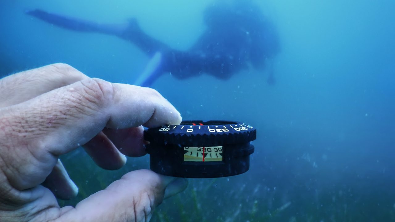
One of the most underrated skills in diving is knowing where you are. Above water you orient yourself effortlessly on buildings, roads and the horizon. Underwater all of that falls away: visibility is limited, the landscape looks the same everywhere, and there is no fixed horizon. Yet you must return to your exit point or your boat, ideally without a long, tiring surface swim against wind and waves.
Navigating underwater rests on two complementary pillars. Natural navigation uses the environment: the direction of the reef, the sun, sand ripples, the depth contour, the current and the waves. Compass navigation uses an instrument to steer exact headings and find them again. The best divers combine both: they navigate on natural cues and use the compass as a check and backup, or the other way around in poor visibility.
Navigation is also an air skill. A diver who gets lost swims back and forth, ascends far from the boat, and makes a long surface swim — all three cost a lot of air and energy, at exactly the moment you have the least. Good navigation is therefore not just comfort, but gas management and safety.
Key concepts
| Term | Short definition | Why it matters |
|---|---|---|
| Natural navigation | Orienting on environmental features | Fast, intuitive, always available |
| Compass navigation | Orienting on magnetic direction | Exact, reliable in poor visibility |
| Heading | The direction you swim, in degrees | The basis of every compass swim |
| Reciprocal | The opposite course, heading ± 180° | The way back |
| Lubber line | Reference line on the compass, points your swim direction | Where you read and hold the heading |
| Sand ripples | Wave pattern in the sand | Usually run parallel to shore |
| Depth contour | Line of equal depth along a slope | Follow it to stay parallel to shore/reef |
| Kick cycle | One full fin stroke (both legs) | A measure to estimate distance |
Understanding navigation
Natural navigation: reading the environment
Before you look at your compass, look around you. The underwater world is full of direction cues once you learn to see them. The reef or bottom slope is the most-used reference: swim out with the reef on your left, and you keep it on your right on the way back; the depth contour (stay at equal depth) keeps you parallel to shore. The sun, in clear water, gives a rough direction and casts directional shadows. Sand ripples, formed by wave action, usually run parallel to the shore, so perpendicular to the ripples points roughly to or from shore. The depth trend is reliable: water almost everywhere gets deeper as you move away from shore, so "shallower = towards shore". Current and waves: if you know the current direction at entry, you know which way "back" is underwater. And fixed structures — a wreck, a big coral head, a gully — are recognisable landmarks you memorise on the way out for the way back.
Natural navigation is like walking in a forest you know: you notice the slope, the sun, a distinctive tree, the path. You don't count steps, you "read" the landscape. Underwater you do exactly the same with reef, sun and ripples.
The dive compass
A dive compass has a few fixed parts you must know. The compass card/needle always points to magnetic north. The lubber line is the fixed line that points in your swim direction; you read your heading along it. The rotating bezel with index markers is set to your chosen heading, so you keep the needle "in the window" and stay straight. You hold the compass flat (level) and straight in front of you, in line with your body, and you turn with your whole body, not just your wrist. Metal (tank, wreck, steel structures) disturbs the compass; keep away from large metal objects while taking a bearing.
Setting a course and finding your way back
The simplest and most-used compass swim is the out-and-back. Point your body in the desired direction and read the heading on the lubber line (say 40°). Turn the bezel so the index markers straddle the needle; now you see immediately if you drift off course. Swim the heading, keeping the needle between the markers, while tracking distance. For the way back, take the reciprocal: 40° + 180° = 220°. Turn around, hold 220° and swim the same distance: you are back at your start.
Two standard patterns build on this. The square (each corner +90°, equal legs): 40° → 130° → 220° → 310°, returning to the start after four legs — the classic navigation exercise. The out-and-back and reciprocal are the foundation of both.
Did you know? You rarely swim dead straight underwater. Current pushes you sideways, you unconsciously kick slightly crooked with your stronger leg, and you look away for a moment. That is why you check the needle continuously and constantly correct small deviations, rather than trusting that you are "swimming straight".
Estimating distance
A heading without distance gets you nowhere. Three ways to estimate, ideally combined: kick cycles (count your full fin strokes; if you know how many equal 10 or 30 m — calibrated in advance on a known distance — you can estimate distance fairly accurately; this is the most-used method); time (at a steady pace you can infer distance from swim time, less accurate); and breaths/air use (a rough relationship, the least reliable). Combine heading, distance and natural landmarks: then the methods correct each other's errors.
Scenario. A diver in Egypt swims a heading of 90° out from the boat onto the house reef, counting kick cycles. They know 20 kick cycles is about 30 metres. After 60 kick cycles they turn on the reciprocal 270° and count back. Despite mediocre visibility they surface right under the boat. Without distance estimation they would not have known when to stop on the way back.
Combining natural and compass navigation
The strongest navigation combines both pillars: navigate on natural cues (reef on one hand, depth contour) and use the compass as a check and backup — take a heading at the start so that in sudden poor visibility or on losing the reef, you still know the way back. In poor visibility the roles reverse: you navigate primarily on the compass and use natural cues (depth, ripples) as support. At entry, remember three things: the outward heading, the rough depth of your route, and one or two landmarks. With those three you almost always get back.
Navigation as a team task
Navigating is not something one person does secretly while the rest follow. Agree who navigates (the "navigator") and who watches as backup. The navigator tracks heading, distance and landmarks; the buddy keeps position and watches the surroundings. When turning or changing course, give a clear signal so the team turns together and nobody is left behind. This keeps navigation a means of staying together.
Real-world examples
The Netherlands (Oosterschelde, Vinkeveen). Often mediocre to poor visibility, sometimes a few metres. Here compass navigation is not a luxury but a necessity; natural landmarks are barely visible. Divers practise out-and-back and square patterns because the reef/slope cannot be relied on if you cannot see it.
Egypt (Red Sea). Excellent visibility and clear house reefs make natural navigation easy: reef on one hand out, the other hand back, and you surface under the jetty or boat. Ideal for learning natural navigation before you need the compass.
Indonesia (muck diving Lembeh, reefs Bali). On sandy muck sites clear landmarks are absent and the depth trend or a compass heading is your anchor. On the reefs you navigate naturally along the wall.
Maldives. On drift dives you navigate less classically (you go with the current), but watch depth, reef edge and the guide; the compass mainly keeps your orientation and helps deploy the DSMB in the right place.
Mozambique (Tofo and Vilanculos). At Tofo the offshore reefs (Manta Reef, Giant's Castle) are dived from the boat; the guide navigates on recognisable reef structures, and with drift and changing visibility a compass orientation is a useful backup. At Vilanculos visibility around the sandbanks can vary strongly with tide and sediment; on murky days compass navigation and following the depth contour are more valuable than on clear days. Both show how visibility decides which pillar leads.
Common mistakes
| Mistake | What goes wrong | How to avoid it |
|---|---|---|
| Not taking a heading at entry | No backup if reef/visibility fails | Always take an outward heading, even on a reef |
| Holding the compass tilted or off body line | Inaccurate, drifting course | Hold it flat and straight in front, turn with your body |
| Only staring at the needle, ignoring surroundings | Missing landmarks, losing buddy | Alternate compass and environment; navigate as a team |
| Not tracking distance | You know the heading but not when to stop | Count kick cycles or use time; calibrate first |
| Miscalculating the reciprocal | Wrong direction back | "Under 180 add, over 180 subtract" |
| Taking a bearing near metal (wreck/tank) | False deflection | Keep away from large metal when taking a bearing |
| Assuming you swim straight | Unnoticed drift from current/kick | Correct continuously; keep the needle in the window |
Pro tips
- Always take an outward heading at entry, even when navigating naturally; it is your insurance if visibility or the reef fails.
- Calibrate your kick cycles on a known distance so you know how many strokes are 10 or 30 metres.
- Hold the compass flat and in your body line and turn with your whole body, not your wrist.
- Alternate compass and environment: navigate on natural landmarks with the compass as a check (in poor visibility, the reverse).
- Remember three things at entry: the outward heading, the route depth, and one or two landmarks.
- Agree who navigates and give clear signals when changing course, so the team stays together.
Frequently asked questions
Name three forms of natural navigation. For example: following the reef/slope (reef on one hand), the position of the sun, sand ripples running parallel to shore, the depth trend (shallower = towards shore), and the current/wave direction.
What is the reciprocal of a heading of 75°, and of 250°? 75° + 180° = 255°; 250° − 180° = 70° ("under 180 add, over 180 subtract").
What is the lubber line on a dive compass for? It is the fixed reference line that points in your swim direction; you read and hold your heading along it.
How do you estimate distance underwater, and which method is most reliable? With kick cycles (counting full fin strokes, calibrated in advance), with time, or with breaths. Kick cycles are usually the most reliable; breaths the least.
When is the compass the primary method rather than a backup? In poor visibility, when natural landmarks are not visible. Then you navigate primarily on the compass and use natural cues (depth, ripples) as support.
Summary
Navigating underwater rests on two complementary pillars. Natural navigation reads the environment: the reef or bottom slope (reef on one hand out, the other hand back), the sun, sand ripples that usually run parallel to shore, the depth trend (shallower is towards shore), the current and recognisable structures. Compass navigation uses the lubber line and rotating bezel to steer exact headings; the way back is the reciprocal (heading ± 180°, under 180 add and over 180 subtract). A heading without distance is useless, so you estimate distance with calibrated kick cycles, time or breaths. The basic patterns are out-and-back and the square (each corner +90°, equal legs). The strongest approach combines both pillars: navigate on natural landmarks with the compass as a check, and reverse those roles in poor visibility. Remember at entry the outward heading, the route depth and a couple of landmarks. Navigation is also a team task and an air skill, because getting lost costs exactly the air and energy you then need most.
The 10 things every diver should know by heart
- Navigation rests on two pillars: natural (environment) and compass (instrument); combine them.
- Always take an outward heading at entry, even when navigating naturally.
- Reciprocal = heading ± 180° (under 180 add, over 180 subtract).
- The lubber line shows your swim direction; hold the compass flat and in your body line.
- Reef on one hand out, the other hand back; the depth contour keeps you parallel.
- Shallower is towards shore; sand ripples usually run parallel to shore.
- Track distance with calibrated kick cycles (or time); a heading without distance is useless.
- Know the patterns: out-and-back and the square (each corner +90°, equal legs).
- In poor visibility the compass is the primary method, not the backup.
- Navigate as a team: agree who navigates and signal clearly on course changes.